In short: Six days on the Faroe Islands in summer light, self-drive with a person of ours on the ground who chooses each island with you the evening before.
Length
6 days
Season
May to September
Longest day
Day 3 · 169 km · 3 h 01 min
A self-drive journey is the lighter alternative to our curated journeys, offered on request, with the same highest level of service. About self-drive journeys
Route
Vágar (Gásadalur), Streymoy (Tórshavn, Kirkjubøur, Vestmanna, Saksun, Tjørnuvík), Eysturoy (Eiði, Gjógv), the Norðoyar (Klaksvík, Kalsoy and Kallur), back to Vágar
Total driving
About 490 km and 9 hours of pure driving
Repeats on the road
The islands are a hub of fjords and dead-end roads, so a strict no-repeat route is not possible here. The trip moves base once (Tórshavn to Klaksvík), each day’s spur ends where it started, and the only long road driven twice is the final run from Klaksvík to the airport on Day 6.
Ferries
Klaksvík to Syðradalur on Kalsoy and back (Day 5, about 20 minutes each way). The ferry carries few cars; sailings are planned by the ground contact.
Tunnels
Three subsea tunnels with tolls, charged to the vehicle; single-lane tunnels on Kalsoy with passing places.
The car
Range Rover, Land Rover Discovery, Mercedes-Benz GLS, Volvo XC90, or a Mercedes-Benz V-Class for larger groups, or comparable, chosen for comfort on every road we send you. Or similar: a vehicle of the same class and standard.
The whole journey, day by day. The numbered points mark where each day ends and the night is spent; select one to jump to that day.
Day 3, Tórshavn to Vestmanna, Saksun and Tjørnuvík and back: 169 km and 3 h 01 min of pure driving, with a two-hour boat trip in the middle. This tour has no long days by the standard of the others. Its demands are different: narrow roads, single-lane tunnels, sheep on the road, and weather that can change four times in an afternoon.
The car
Range Rover, Land Rover Discovery, Mercedes-Benz GLS, Volvo XC90, or a Mercedes-Benz V-Class for larger groups, or comparable, chosen for comfort on every road we send you.
Or similar: a vehicle of the same class and standard.
Grade A, premium compact SUV, automatic, current or previous model year. Smaller is better here: village roads are narrow, the Kalsoy tunnels are single-lane, and the Kalsoy ferry has room for few cars. Tunnel tolls are charged to the plate through the rental.
On the ground, every day
The vehicle is handed over at Vágar airport by our ground contact or a supplier agent, with a walk-through of the tunnels and the single-lane rules; collection at the airport on Day 6.
One named person on the ground for the whole trip, reachable at any hour by phone and message.
The evening pulse: tomorrow’s weather and road status from the Faroese road authority, the ferry plan and the first departure time; a morning check before the car leaves. On these islands the pulse matters more than anywhere else in the line, because the weather moves fast and the best day for each island is chosen the evening before.
A route pack: day cards, offline maps and the Google Earth file of the route.
Curated stays: the best rooms in Tórshavn, and a private house or the best available rooms near Klaksvík.
Evenings at the table
Dinner: Night 2, a dinner in a Faroese home, a tradition here where families open their table to guests, or a private chef in the house.
With a private guide
We recommend a private guide on the Faroe Islands, and we say so on the first call, because the best walks cross private land, the weather decides each day, and a local guide knows which valley is clear. Three levels are offered: guided walks only, a guide for Days 3 and 5, or a private driver-guide for the whole stay. Self-drive suits guests who want the islands at their own pace; the ground contact chooses the order of the days with them, every evening.
Guided days to add
Guided days: the walk above Sørvágsvatn (Day 1), the bird cliffs by boat (Day 3), Slættaratindur (Day 4), Kallur on Kalsoy (Day 5).
The days
Day 1 Vágar to Tórshavn, by Gásadalur
69 km, 1 h 15 min.
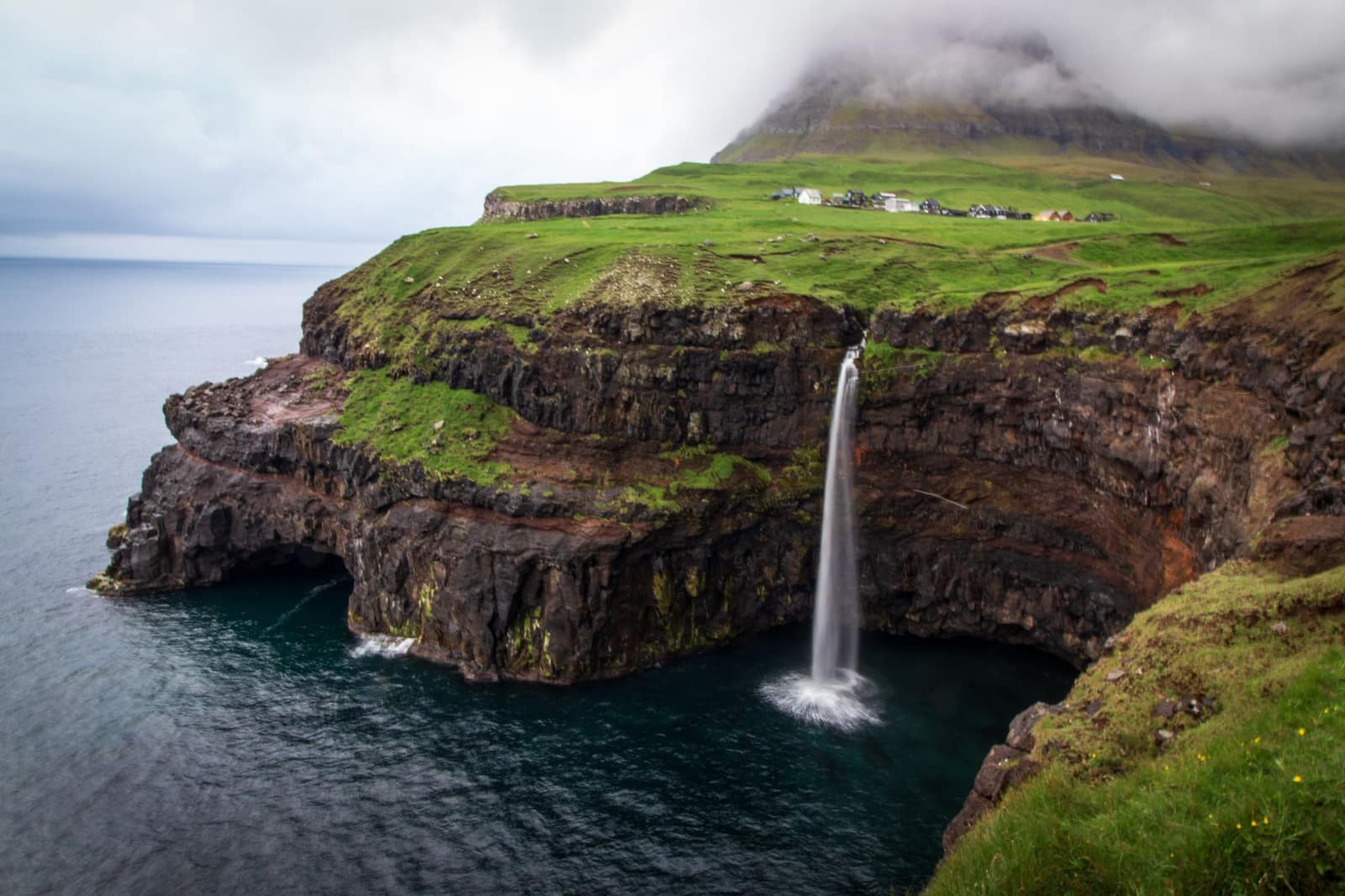
The airport sits on Vágar, the island the planes come in over between mountain walls, and the first drive is fifteen minutes to Gásadalur. For centuries the village could only be reached over the mountain or by sea; a road tunnel now reaches it. Beside it the waterfall Múlafossur drops from the grass straight into the Atlantic, and on a clear day the island of Mykines lies on the horizon.
For those who want to walk on the first afternoon, a guide takes you above the lake of Sørvágsvatn, which from one point on the cliffs seems to hang above the sea. Then the road crosses to Streymoy through the subsea tunnel and reaches Tórshavn, a small capital with turf roofs on the old buildings of Tinganes, the rocky point where the islands’ assembly met from Viking times.
Along the way
Vágar Airport Start of the day
Vágar Airport is the only airport in the Faroe Islands. It was completed in 1943, during the Second World War, and regular air service began in 1963.
From the airport it takes about 15 minutes to drive to Gásadalur. The road east to Tórshavn passes through the Vágatunnilin, the subsea tunnel between Vágar and Streymoy.
Gásadalur and Múlafossur A stop
Gásadalur is a village on Vágar with a panoramic view over the sea to Mykines. Before the road tunnel was built, the mountain path was its only link to the outside world, and the postman carried the post over it three times a week.
The waterfall Múlafossur falls straight off the cliffs here, one of the most photographed views in the Faroe Islands. Parking is available at the village.
Sørvágsvatn (Leitisvatn) On the way
Sørvágsvatn, also called Leitisvatn, is the largest lake in the Faroe Islands, about 3.4 km² in area. It lies on Vágar close to the ocean.
From a particular angle the lake looks as if it hovers over the sea, and it has been nicknamed the lake above the ocean. At the seaward end the waterfall Bøsdalafossur, 30 m high, flows directly into the Atlantic.
Tórshavn End of the day
Tórshavn, named after the Norse god Thor, is the capital and largest town of the Faroe Islands, on the southeast coast of Streymoy.
The old part of town covers Reyni, a small peninsula in the centre, and its outermost point is Tinganes. The peninsula divides the harbour into two bays, and the Faroese government has its seat in the red buildings on Tinganes.
The road of the day, on the coast. Select a point to read about the place.
The day, hour by hour
On arrival: Land at Vágar; vehicle handover
12:30Gásadalur and Múlafossur
13:30Lunch on Vágar
14:30Guided walk above Sørvágsvatn (option, about 3 hours)
17:45Drive to Tórshavn
18:45Check in
20:00Dinner reserved
Plan B. In low cloud, the walk above the lake is pointless and is dropped; the afternoon moves to Tinganes and the old town on foot.
Night: Tórshavn
Day 2 Tórshavn and Kirkjubøur
23 km, 30 min, Tórshavn to Kirkjubøur and back. Spur by design.
Kirkjubøur, a few kilometres south of the capital, was the seat of the islands’ bishops in the Middle Ages. The walls of a stone cathedral begun around 1300 still stand roofless by the sea, beside a small medieval church that is still in use and a farmhouse of black timber that has been lived in for centuries.
The afternoon is in Tórshavn: the harbour, the narrow lanes of Tinganes, and a gallery of Faroese painting whose landscapes are the ones you will drive through tomorrow. In the evening, if it is booked, dinner is in a Faroese home, at a family’s own table, or a private chef cooks in the house.
Along the way
Tinganes Start of the day
Tinganes is the historical core of Tórshavn, a flat rocky outcrop that divides two harbours. It is one of the oldest, if not the oldest, parliamentary meeting places in the world, and the Viking parliament met here every summer to settle matters of national importance.
Today the red wooden buildings, some with turf roofs, house the Faroese government. Many of the old houses on Reyni, the peninsula where Tinganes lies, were built in the 16th and 17th centuries.
Kirkjubøur A stop
Kirkjubøur on Streymoy was the seat of a Catholic bishop in the Middle Ages. The ruins of Magnus Cathedral, built around the year 1300, stand by the sea, and recent investigations suggest the cathedral was completed and consecrated and stayed in use until the Reformation.
The parish church was built in the 13th century and is the only medieval church in the country still in use. The King’s yeoman’s farm stands on the site of the old bishop’s residence.
Listasavn Føroya A stop
Listasavn Føroya is the main museum for Faroese art in the Faroe Islands. Its collection holds about 2,800 works, mostly paintings, together with graphics, sculpture, installations and textiles, and the oldest works date from the 1830s.
The museum was established in 1989 and stands at Gundadalsvegur 9 in Tórshavn.
Havnar Kirkja End of the day
Havnar Kirkja, the cathedral of Tórshavn, was inaugurated in 1788 and stands on the northern part of Tinganes. It is white with a slate roof and is the second-oldest church in the Faroe Islands.
It replaced Christian IV’s church from 1609, and it has been the Faroese cathedral since 1990.
The road of the day, on the coast. Select a point to read about the place.
The day, hour by hour
10:00Leave Tórshavn
10:20Kirkjubøur; the cathedral walls, the church and the farmhouse
12:30Back in Tórshavn; lunch
14:00Tórshavn on foot; the art museum
19:30Dinner in a Faroese home, or a private chef (option)
Plan B. If Day 3’s weather looks better today, the ground contact swaps Days 2 and 3 the evening before; Kirkjubøur works in any weather.
Night: Tórshavn
Day 3 Streymoy: the bird cliffs, Saksun and Tjørnuvík
169 km, 3 h 01 min. Longest drive of the tour.
From Vestmanna a boat runs under the bird cliffs on the west coast of Streymoy, where the rock rises hundreds of metres straight out of the sea and the boat goes into caves and through channels between the stacks. In summer the cliffs are loud with fulmars, guillemots and puffins.
Saksun is a handful of turf-roofed houses and a church at the head of a valley, above a lagoon that fills and empties with the tide; at low water you can walk out across the sand toward the sea. At the end of the next valley is Tjørnuvík, the northernmost village on the island, with a black sand beach. Across the sound stand two sea stacks, the giant and the witch, who by the old story came to tow the islands to Iceland and were caught by the sunrise and turned to stone.
Along the way
Eystaravág and Vestaravág Start of the day
The headland of Tinganes separates the harbour of Tórshavn into two bays, Eystaravág and Vestaravág. From the earliest times Tórshavn has been the most important trading post of the islands.
The Løgting, the old parliament, was first held in the open air on Tinganes. From here the day’s road runs north and west across Streymoy to Vestmanna, Saksun and Tjørnuvík.
Vestmanna A stop
Vestmanna is a village on Streymoy and the place from which boat trips go to the Vestmannabjørgini, the sea cliffs and grottoes. The cliffs are 700 m high and rise straight from the ocean.
The boat tour lasts about two hours and passes deep sea caves and narrow straits. In summer thousands of seabirds nest on the cliffs and in the caves, among them puffins, razorbills, guillemots and fulmars.
Saksun A stop
Saksun lies in a natural circular amphitheatre high above a tidal lagoon. At low tide you can walk along the sandy shore of the lagoon around the headland, so the tide decides when the visit works best.
The village church was built in 1858. Dúvugarðar, the old farmhouse, has kept its original interior and is both an active sheep farm and a museum, so please walk on the designated paths and respect the farmers and their work.
Tjørnuvík A stop
Tjørnuvík lies on the northernmost part of Streymoy, with high mountain slopes on three sides. It is counted among the oldest settlements in the Faroe Islands, and excavations in 1956 found a ring-headed pin from about the 10th century.
A marked village trail runs from Tjørnuvík to Saksun. The bay outside the village is well suited to surfing, and from here there is a view toward Risin og Kellingin.
Risin og Kellingin On the way
Risin og Kellingin, the Giant and the Witch, are two sea stacks north of Eiði, off the Kollurin peninsula on the north coast of Eysturoy. They can be seen across the sound from Tjørnuvík.
By the legend the two trolls were to drag the Faroe Islands closer to Iceland, but the sunrise turned them to stone before they could finish.
Gongin, Tinganes End of the day
Gongin is a lane on Tinganes, in the old part of Tórshavn. The old town is known for its black-tarred houses with turfed roofs along narrow lanes, and many of the houses on Reyni were built in the 16th and 17th centuries.
The red buildings on the point house the Faroese government, and the harbour lies on both sides.
The road of the day, on the coast. Select a point to read about the place.
The day, hour by hour
09:00Leave Tórshavn
09:45Vestmanna
10:00Bird cliffs by boat (option, about 2 hours)
12:15Lunch in Vestmanna
13:15Leave Vestmanna
14:10Saksun; the walk to the lagoon at low tide
15:40Tjørnuvík
16:30Leave Tjørnuvík
17:30Back in Tórshavn
Plan B. If the sea is too rough for the boat, the morning goes to Saksun at low tide and the afternoon to Tjørnuvík. The ground contact checks the tide table for the Saksun walk.
Night: Tórshavn
Day 4 Eysturoy to Klaksvík, by Eiði and Gjógv
106 km, 1 h 50 min.
The road to Eysturoy goes under the sea, through a tunnel that meets an underwater roundabout lit with blue light and a ring of sculpture. At Eiði the viewpoint looks back at the giant and the witch from the other side. Slættaratindur, the highest mountain on the islands at 880 metres, rises behind the village, and on a clear day a guide can take you to the top.
Gjógv is a village built around a narrow sea gorge that serves as its harbour; the boats are winched up a slipway between the rock walls. From Gjógv the road turns east and goes under the sea again to Klaksvík, the fishing town of the northern islands, where the trip moves base.
Along the way
Reyni Start of the day
Reyni is the old and historic part of Tórshavn, on a small peninsula in the centre of the town. Its outermost point is Tinganes, where the red government buildings stand.
The peninsula splits the harbour into two bays, Eystaravág and Vestaravág. Until 1788 the parish church of the town stood out here on Reyni. From here the day’s road leaves Tórshavn toward the Eysturoy tunnel.
Eysturoyartunnilin On the way
The Eysturoy tunnel opened on 19 December 2020. The network is about 11.2 km long and links Tórshavn with Eysturoy, and its lowest point is 187 m below sea level.
In the middle is the world’s first undersea roundabout. Its central pillar is natural rock left from the blasting, lit in sea-blue light and decorated by the Faroese artist Tróndur Patursson. Branches lead on to Strendur and Runavík.
Brúgvin um Streymin On the way
The bridge over the Streymin crosses the Sundini sound between Streymoy and Eysturoy. It stands between the hamlet of Nesvík on Streymoy and the area of Norðskáli and Oyrarbakki on Eysturoy.
The bridge was built in 1973 and joins the two islands by road.
Eiði A stop
Eiði lies in a hollow at the foot of the Eiðiskollur peninsula, with access to the sea on both sides. The two sea stacks Risin og Kellingin, the Giant and the Witch, stand to the north.
The oldest building in the village is Látrið, a stone house from about 1840, and it now serves as the local museum. Slættaratindur, the highest mountain in the country at 880 m, rises nearby, and structures from the Second World War stand on top of Eiðiskollur.
Slættaratindur On the way
Slættaratindur is the highest mountain in the Faroe Islands at 880 m. Older surveys gave 882 m, and the second highest peak, Gráfelli, is 856 m.
The hike is rated moderate and takes two to two and a half hours over five to six km. One starting point is Eiðisskarð, the pass between Eiði and Funningur. On a clear day all 18 islands can be seen from the top, and climbing it on 21 June, the longest day of the year, is a tradition.
Gjógv A stop
Gjógv is the northernmost village on Eysturoy. Its name comes from the deep gorge, the gjógv, that cuts into the land at the village.
The gorge is 200 m long and forms a natural harbour for small boats. Trap counts it among the major tourist attractions of the Faroe Islands.
Klaksvík End of the day
Klaksvík is the main town on Borðoy, in the Northern Islands, on a low isthmus between high mountains. Four villages, Vágur, Myrkjanoyri, Gerðar and Uppsalir, merged to form the town in 1938.
It has an important harbour with a fishing industry and a modern fishing fleet. Since April 2006 the subsea tunnel Norðoyatunnilin has linked Klaksvík with Leirvík on Eysturoy.
The road of the day, on the coast. Select a point to read about the place.
The day, hour by hour
09:00Leave Tórshavn
09:50Eiði; the viewpoint
10:30Slættaratindur with a guide (option, about 3 hours)
13:45Gjógv; lunch
15:00Leave Gjógv
15:50Arrive Klaksvík
Plan B. If Slættaratindur is in cloud, the time goes to a walk along the gorge and cliffs above Gjógv.
Night: Klaksvík
Day 5 Kalsoy and the Kallur lighthouse
49 km, 1 h 29 min including the ferry both ways.
Kalsoy is a long, thin island, and its road runs through a series of single-lane tunnels, each with a passing bay, from village to village. At Mikladalur a bronze figure of a seal woman stands on the rocks, from the old story of a seal who came ashore as a woman and was kept on land when a farmer hid her skin.
At the northern end, from Trøllanes, the path to the Kallur lighthouse climbs for about an hour over open grass to a red lighthouse on a ridge, with the cliffs falling away on both sides. Access is managed by the landowners, a fee may apply, and the ridge is no place to be in wind or cloud; with a guide it is a walk you will remember. The last ferry back is planned before the guests leave Klaksvík.
Along the way
Klaksvík harbour, Kalsoy ferry Start of the day
A car ferry sails between Klaksvík and the ferry landing at Syðradalur on Kalsoy.
On the island a 17 km road passes through four tunnels from the ferry terminal at Syðradalur to Trøllanes in the north. Visit Faroe Islands points out that the roads are narrow and that parking is limited.
Mikladalur and the seal woman A stop
Mikladalur is widely known for the legends tied to the village, above all that of Kópakonan, the seal woman. By the story, seals may come ashore once a year on the twelfth night of Christmas, take off their skins and play, sing and dance in human form, but only until the sun rises.
A statue of Kópakonan by the Faroese sculptor Hans Pauli Olsen stands on Stórakneysa by the sea. It was unveiled on 1 August 2014.
Trøllanes A stop
Trøllanes is the northernmost village on Kalsoy, and from it you can see the northernmost Faroe Islands. It is the end of the island’s road and the starting point of the walk to the lighthouse at Kallurin.
The village has a smithy workshop that is at least 200 years old, perhaps 300, where visitors can watch a smith at work. Some of the best smiths in the Faroe Islands have come from Trøllanes and Mikladalur.
Kallurin lighthouse A stop
Kallurin is a modest lighthouse on the northern tip of Kalsoy, standing before the coastal cliffs.
The walk starts in Trøllanes and is rated moderately easy, and the return trip usually takes between one and a half and two hours. Visit Faroe Islands counts it among the most popular hiking experiences in the Faroe Islands.
Christianskirkjan, Klaksvík End of the day
Christianskirkjan is the church of Klaksvík, built in 1963 to a design by Peter Koch. Trap marks it as the start of the contemporary phase of Faroese building.
Klaksvík is the main town on Borðoy and sits on a low isthmus between high mountains, with the only natural harbour in the Northern Islands.
The road of the day, on the coast. Select a point to read about the place.
The day, hour by hour
09:00Ferry from Klaksvík to Syðradalur (sailing set by the ground contact)
09:45Mikladalur; the seal woman
10:30Trøllanes; guided walk to Kallur (option, about 2 hours return)
12:45Lunch on Kalsoy, picnic from the hotel
14:00Ferry back to Klaksvík
15:00Afternoon free in Klaksvík
Plan B. If the Kallur ridge is in cloud or wind, the walk is dropped and the island is driven and seen from the road. If the ferry is full, the ground contact books the next sailing.
Night: Klaksvík
Day 6 Klaksvík to Vágar airport
77 km, 1 h 22 min.
The last drive runs back through the subsea tunnels and across Streymoy to Vágar, the one road of the trip that is driven twice, and in changing light it is never the same road. The car goes back at the airport, taken by our ground contact.
On the way out the plane turns over the islands, and the places you drove to are laid out below: the fjords, the villages at the end of their roads, the cliffs where the birds nest.
Along the way
Klaksvík harbour Start of the day
Klaksvík sits on a low isthmus between high mountains on Borðoy, and it is the only place in the Northern Islands with a natural harbour. Trap calls it the fishing capital of the Faroe Islands.
The town is home to the music festival Summarfestivalurin. The road back toward Vágar leaves from here through the tunnel to Eysturoy.
Norðoyatunnilin On the way
The Norðoyatunnilin opened on 29 April 2006. It is 6,200 m long, with its lowest point 160 m below sea level, and it joins Klaksvík on Borðoy with Leirvík on Eysturoy.
It is a toll tunnel, and when you drive from Klaksvík the charge covers both directions.
Vágatunnilin On the way
The Vágatunnilin opened on 10 December 2002. It is 4,900 m long, with its lowest point 105 m below sea level, and it joins Streymoy with Vágar and the airport.
It is a toll tunnel, and when you drive from Vágar the charge covers both directions.
Vágar Airport, arrival and departure End of the day
Vágar Airport is the only airport in the Faroe Islands. It was completed in 1943 and regular air service began in 1963.
The car goes back here before the flight. Gásadalur is about 15 minutes’ drive from the airport if there is time for a last look at the Atlantic.
The road of the day, on the coast. Select a point to read about the place.
The day, hour by hour
3 h before departure: Leave Klaksvík
90 min before departure: Vehicle handed back at Vágar airport
Plan B. If the flight is delayed for weather, which happens on these islands, the ground contact holds a room near the airport and rebooks.
Request this journey
Tell us your month and your party, and a founder replies within 24 hours with the journey shaped to you. Prices are shared in that reply.